Current Status:
Deployment-Ready for the Isle of Wight Use Case – Successfully delivering its intended functionality to stakeholders.
Future Development:
Ongoing Work Toward Scaling & Open Adoption – Expanding data sources, improving interoperability, and scaling geographically.

Overview
What it is?
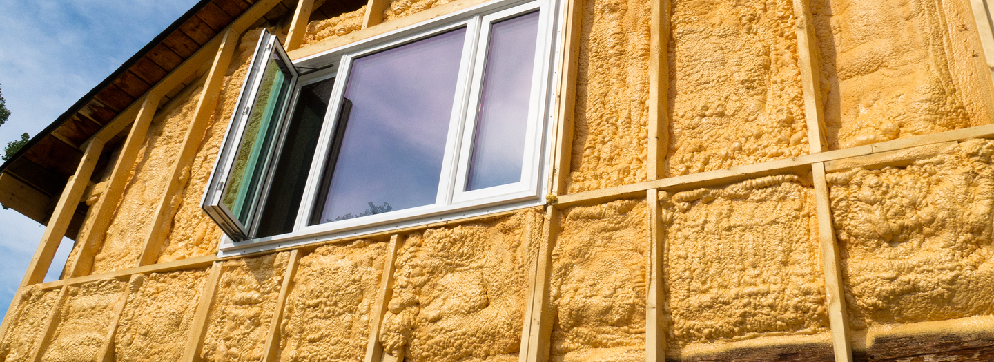
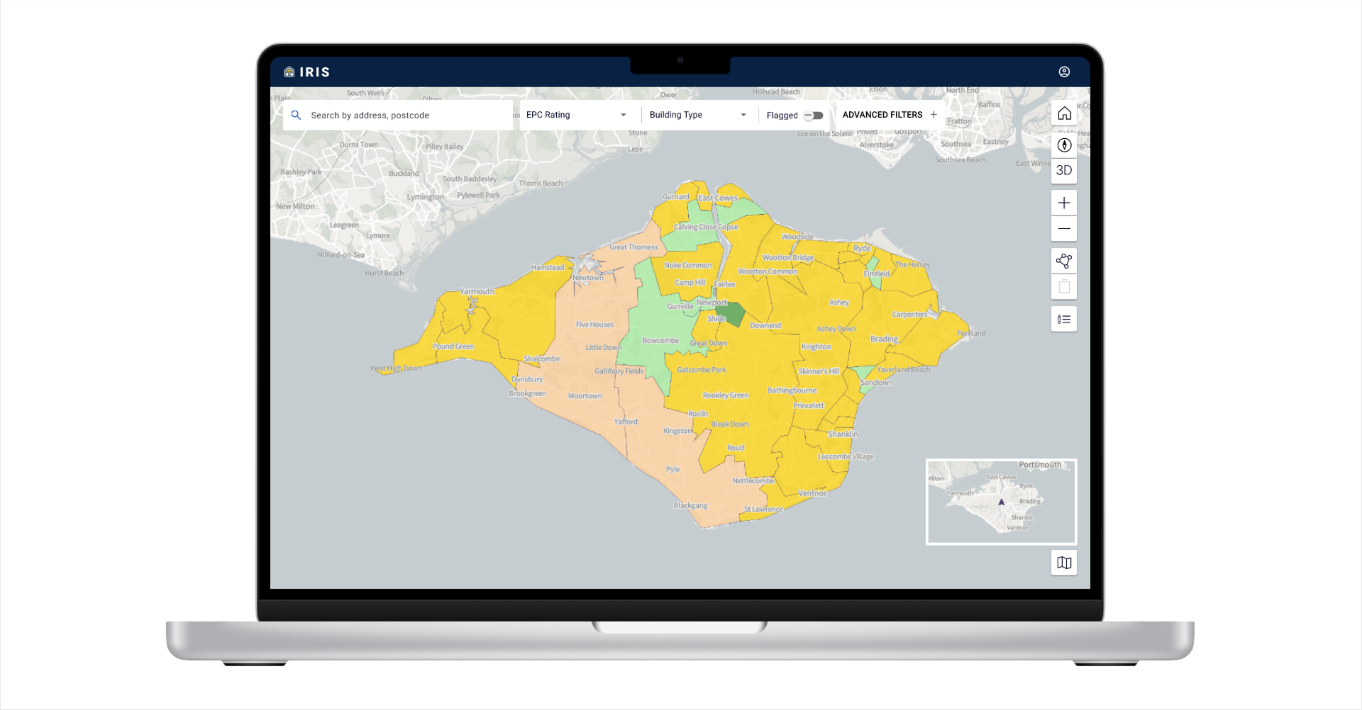
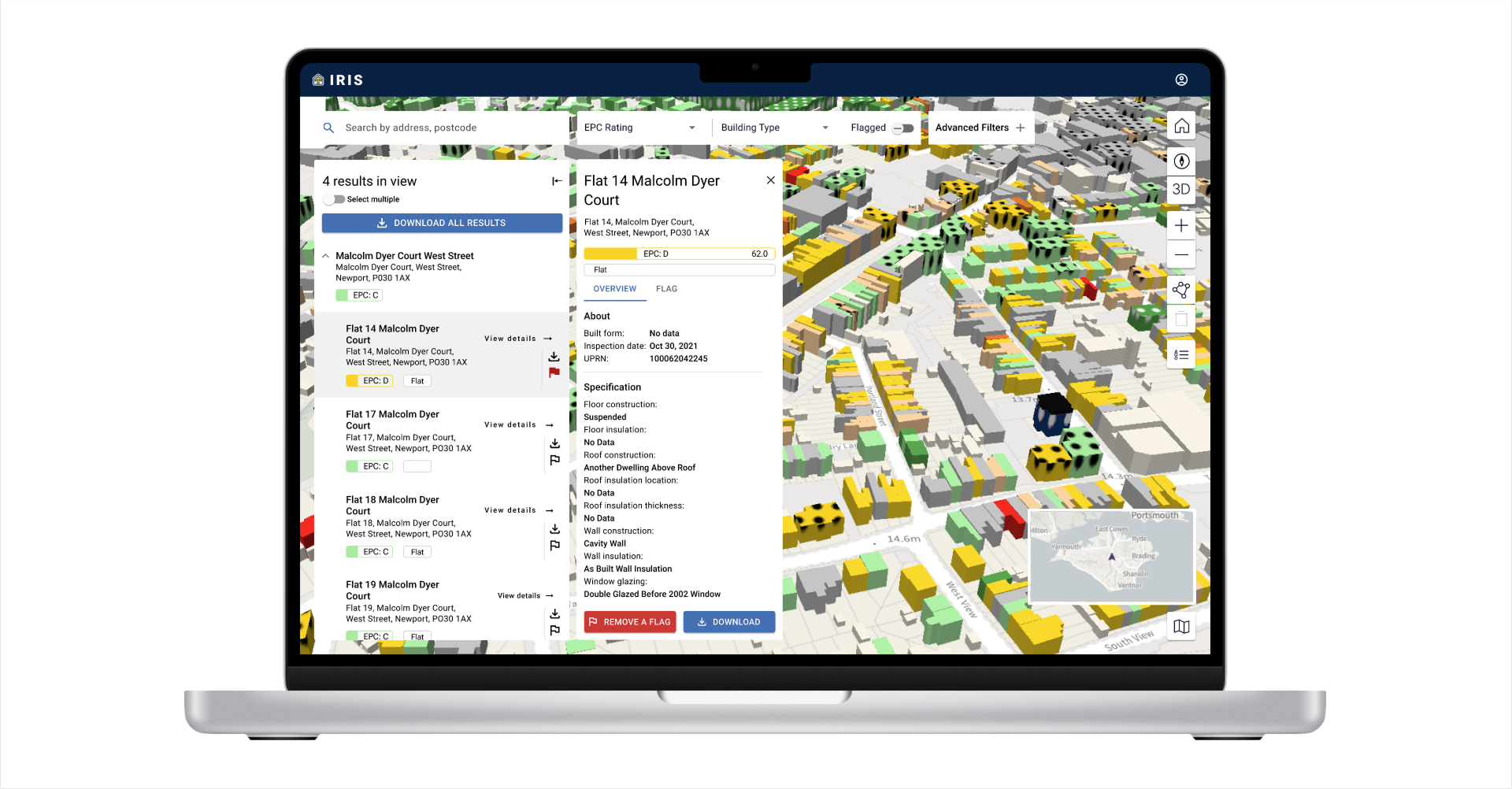
IRIS is a digital tool designed to support data-driven decision-making for retrofitting domestic properties by identifying homes that could benefit from energy efficiency improvements. It enables stakeholders to assess housing stock based on energy performance data to help target funding schemes and policy interventions more effectively.
The problem it addresses
Many homes in the UK require retrofitting, but identifying the right properties for intervention is challenging. Current funding schemes like Energy Company Obligation (ECO) often struggle with lead generation and coordination, leading to inefficiencies and delays. IRIS simplifies this process, allowing policymakers, local authorities, and industry to prioritise homes based on available data and improve funding allocation, planning, and implementation.
How it contributes to programme vision
IRIS demonstrates how digital models and interoperable data-sharing can enhance decision-making, improve market visibility, and enable scalable solutions. The tool currently ingests and visualises data from Energy Performance Certificate (EPC) records and Ordnance Survey mapping, providing an initial framework for more advanced policy analysis and impact assessment. As more data sources are integrated, IRIS will offer deeper insights into housing, energy efficiency, retrofit work undertaken, and policy modelling.

Who we work with
Lead stakeholders and collaborators
- Isle of Wight Council
- Retrofit companies
- Third-sector organisations
- National Health Service England

Why we are doing this
Strategic objectives
The IRIS demonstrator serves two core purposes—one is programme-driven, focused on developing key NDTP assets, and the other is use case-driven, addressing a significant real-world challenge in energy efficiency of buildings and retrofitting.
Advancing Technical Capabilities
IRIS is a key testbed for developing and refining the National Digital Twin Programme (NDTP) core programme assets, ensuring the robustness, scalability, and interoperability of the digital twin ecosystem. Through this demonstrator, we are:
- Testing and validating the Integration Architecture (IA) by ingesting large volumes of data and ensuring the system can handle increasing scale and complexity.
- Expanding the Information Exchange Standard (IES) by developing IES:Building, a 4D ontology extension for the built environment that enables structured, standardised data representation.
- Developing critical APIs for the IA, supporting seamless data integration and interoperability across different sources and systems.
Delivering reusable programme resources, including playbooks that:
- Guide use case development for digital twins and other similar technologies
- Support data discovery methodologies, helping organisations identify and map relevant datasets.
Demonstrating the potential of interoperable data, showcasing how scaling ingestion, mapping data to IES, and adding features over time enhances value exponentially.
Addressing the real-world challenge of domestic retrofitting
While this demonstrator plays a key role in developing NDTP assets, it was also chosen as energy efficiency of domestic properties has a significant impact on the UK’s carbon footprint, making retrofitting a national priority. This demonstrator:
- Directly supports decarbonisation and net-zero efforts by accelerating the retrofitting of UK housing stock.
- Improves access to retrofitting funding (e.g., ECO) by connecting available schemes with those most in need—particularly vulnerable populations at risk of fuel poverty.
- Speeds up the process of identifying properties requiring retrofits, enabling retrofit companies, local authorities, and policymakers to target resources more efficiently and deploy interventions faster.
By combining technical development with real-world impact, IRIS demonstrates both the power of interoperable data and the tangible benefits digital twins technologies can unlock when applied at scale.
Expected impact
- More efficient allocation of retrofitting funds through better-targeted interventions.
- Faster decision-making for policymakers, reducing administrative burden.
- Ability to understand and monitor retrofit work undertaken.
- Stronger integration with environmental and social impact initiatives, improving health and quality of life for vulnerable populations.

Key innovations
- Geospatial data integration enhancements to improve location-based decision-making.
- Planned expansion to incorporate additional datasets such as Met Office climate data and TrustMark Energy Performance Report (EPR) records.
- Future policy simulation capabilities, allowing policymakers to model and compare different intervention strategies before implementation.

Technical details
Architecture & frameworks used:
- Built using NDTP’s IA and the IES for scalable, interoperable data-sharing.
- Uses continuous integration/continuous delivery (CI/CD) pipelines for improved deployment, testing, and scalability.
Where to find the code:
The IRIS stack is composed of four interrelated repositories:
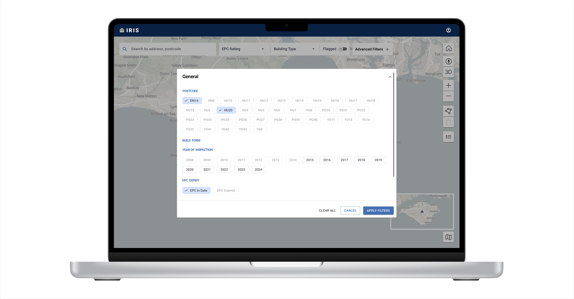
This is the client-side application that users interact with. Built using Angular, it renders geospatial housing data, overlays EPC and material information, and provides interactive filtering and selection tools. Designed with performance and clarity in mind, it presents IA-fed data in a way that supports quick insight and decision-making.
The backend service for the visualisation layer. This Python-based API provides REST endpoints to read from and write to the IA Node, enabling dynamic queries and state changes. It also supports OpenAPI documentation and routes all visualisation data calls through a secure and scalable middleware layer.
An ETL pipeline that pulls raw data from public APIs (e.g. EPC and Ordnance Survey), cleans and transforms it using dbt, and stores it in a structured format (CSV in S3) ready for further processing. The pipeline is managed using Airbyte and is intended to be reproducible, modular, and extendable.
This repository contains two core data pipelines that transform energy performance and geographic datasets into RDF format aligned with the Information Exchange Standard (IES). Specifically, it uses IES:Building, a domain ontology developed through this demonstrator to represent data about the built environment—particularly energy performance characteristics.
The pipelines include:
- An address profiling pipeline that ingests EPC assessment data and converts it to RDF using IES:Building concepts (e.g. insulation type, SAP ratings)
- A lat-long pipeline that processes spatial identifiers (e.g. TOIDs, coordinates) for alignment with geospatial referencing
Both pipelines integrate with Kafka for ingestion and publishing, and are intended to serve as reference implementations for structured, interoperable data exchange using the IES framework.

Get involved
There are multiple ways to engage with IRIS, whether you are part of government, industry, academia, or the technical community:
- Collaboration and partnerships – Government bodies, housing providers, local government, and industry partners can contribute data, expertise, or funding to expand IRIS’s capabilities or integrate it into regional and national retrofitting programmes.
- Adoption – Organisations can adopt or adapt IRIS for their own needs, ensuring the tool is reused and extended for maximum impact.
- Testing & Feedback – Organisations and individuals can validate use cases, test functionality, and provide feedback to improve usability and effectiveness.
- Knowledge Sharing – Contributions to best practices, case studies, and policy recommendations are encouraged to guide future expansion.
If you’re interested in collaborating, adopting, or contributing, get in touch via ndtp@businessandtrade.co.uk or explore the open-source codebase on GitHub.